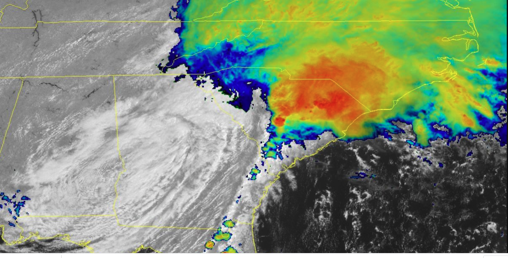
While Hurricane Sally has been downgraded to a tropical depression, the slow moving storm still packs plenty of power to wreak some havoc on South Carolina today — with several inches of rain, flash flooding and even a few tornadoes threatening the Midlands and the Upstate today.
On Thursday morning, Sally‘s center was slowly creeping across eastern Alabama, while the storm system stretched all the way up the Carolinas, according to the National Hurricane Center.

A flash flood warning is in effect for Southeastern Oconee and Southwestern Pickens in the upstate and the entire Columbia, SC area, West Columbia, and Lexington County through 1:45 p.m.
The National Weather Service in Columbia issued a Tornado Watch following SC counties effective until 6 p.m.:
AIKEN                BAMBERG             BARNWELL
CALHOUN              CHESTERFIELD        CLARENDON
DARLINGTON           DILLON              FLORENCE
GEORGETOWN           HORRY               KERSHAW
LEE                  LEXINGTON           MARION
MARLBORO             ORANGEBURG          RICHLAND
SALUDA               SUMTER              WILLIAMSBURG
The NWS also issued a flash flood watch through 2 p.m. Thursday for the following Midlands and Upstate counties:
Abbeville County, Northeastern Aiken County, Anderson County, Bamberg County, Eastern Barnwell County, Calhoun County, South Central Fairfield County, Southwestern Kershaw County, Lexington County, Southeastern Newberry County Western, Orangeburg County, Richland County, Eastern Saluda County and Central Sumter County.
Tornado warnings have been fired off throughout Thursday morning for several midlands counties. For the latest watches and warnings updates, click here.
Here’s a look at SC this morning:
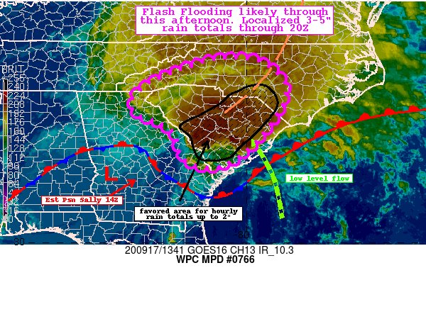
Rain
Sally is expected to dump several inches of rain across the Midlands and Upstate, with lesser amounts in the Lowcountry.
The Midlands expects to see the most rain in South Carolina with 5-7 inches possible in some areas, and 4-6 inches in Columbia. Here’s a map showing total rainfall from the storm:
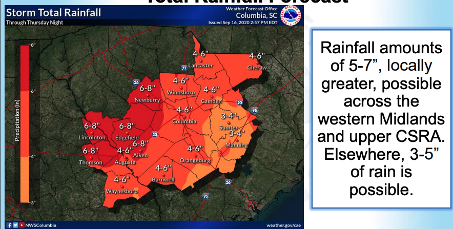
According to the NWS-Columbia, this amount of heavy rainfall throughout Thursday will likely lead to flash flooding across central South Carolina — especially across the Central Savannah River Area and western Midlands.
“Water may enter homes or businesses, especially in flood prone locations,” the NWS update said. “Small streams and creeks may rise
rapidly and overflow their banks.”
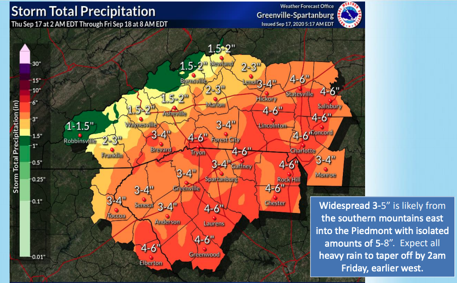
Here’s a map showing lesser amounts of rain in the Upsate, but significant enough to cause flash flooding in “urban areas, low-lying areas and
roads adjacent to streams,” likely to impact bridges and structures.
Tornadoes/ Wind
Isolated tornadoes are possible throughout Thursday afternoon in the Upstate and Midlands.
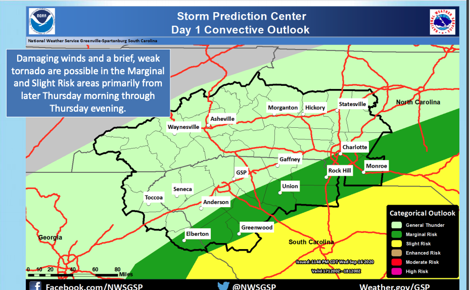
Forecasters predict maximum windgusts Thursday afternoon topping at around 22 MPH in Greenville and Columbia and 24 MPH in Augusta.
Wind is not expected to be a significant impact from this storm, NWS-Columbia officials said.
Here is the full weather briefing for Sally from NWS Columbia:
Here is the full weather briefing for Sally from NWS- Greenville-Spartanburg:
Lowcountry
Unusually high tides not affiliated with Sally are expected throughout the weekend. Coastal flooding is likely in the Lowcountry.
Stay tuned.. we will keep y’all updated throughout the day — and stay safe!
***
WANNA SOUND OFF?
Got something you’d like to say in response to one of our articles? Or an issue you’d like to address proactively? We have an open microphone policy! Submit your letter to the editor (or guest column) via email HERE. Got a tip for a story? CLICK HERE. Got a technical question or a glitch to report? CLICK HERE.
