Here comes Nana!?
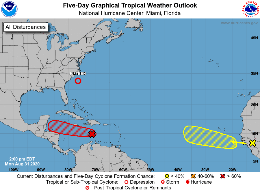
Tropical Depression 15 formed off the South Carolina coast Monday afternoon and it will likely turn into Tropical Storm Nana within the next 24 hours, according to forecasters at the National Hurricane Center.
The good news is Nana shouldn’t be stirring up any trouble — the tropical storm (if it forms) will stay well off the coast with minimal impact to South Carolina, according to forecasters.
As of 5 pm. Monday, Tropical Depression 15 was approximately 190 miles south-southwest of Cape Hatteras, North Carolina with maximum sustained winds of 35 mph.
“The greatest risk will be to bathers and boaters along the East Coast and Bermuda. In the U.S. an easterly flow of air, created by the tropical depression and an area of high pressure over New England, will push ocean water westward,” Accuweather reported. “In addition to stiff breezes, rough surf and frequent and strong rip currents are in store, especially from the Carolinas to Long Island, regardless of development.”
Take a look at the spaghetti models for a possible Nana..

Meteorologists are watching two other disturbances that could develop into tropical storms later this week. The Red X (Invest 99) could also form this week and become Nana if Tropical Storm 15 doesn’t take it first.

The disturbance in the Caribbean has an 80 percent chance of cycle formation in the next 5 days, while the system off Africa has about a 30 percent chance of formation this week.

In early August, forecasters revamped their 2020 hurricane predictions and said this season could get crazy.
Meteorologists at the National Oceanic and Atmospheric Administration (NOAA) are urging Americans on the East Coast to prepare for an “extremely active” hurricane season in the Atlantic.
Just how active are we talking?
“This is one of the most active seasonal forecasts that NOAA has produced in its 22-year history of hurricane outlooks,” U.S. Secretary of Commerce Wilbur Ross said in a news release Thursday.
The updated report predicts a whopping 19-25 named storms. Researchers at Colorado State University also upped their 2020 hurricane forecast this week, now calling for 24 named storms this season.
That means we would run out of letters in the alphabet before the 2020 hurricane season ends.
“Only 21 storm names are allotted each year because the letters Q, U, X, Y and Z are not used,” CBS News reported. “As a result, if 24 tropical storms are indeed named, the National Hurricane Center will have to employ the Greek alphabet for overflow. This has only happened one time on record — in 2005 when the Atlantic experienced 28 named storms.”
NOAA’s forecast calls for 7 to 11 of the storms to become hurricanes (with winds 74 mph or greater) and 3 to 6 of the named storms would be major hurricanes (with winds of 111 mph or greater).
“This year, we expect more, stronger, and longer-lived storms than average, and our predicted ACE range extends well above NOAA’s threshold for an extremely active season,” Gerry Bell, Ph.D., lead seasonal hurricane forecaster at NOAA’s Climate Prediction Center, said in the release.
September is typically peak hurricane season in the Atlantic.
While South Carolina might not be affected by Nana, we can expect hot temperatures this week, especially in the Lowcountry.
***
WANNA SOUND OFF?
Got something you’d like to say in response to one of our articles? Or an issue you’d like to address proactively? We have an open microphone policy! Submit your letter to the editor (or guest column) via email HERE. Got a tip for a story? CLICK HERE. Got a technical question or a glitch to report? CLICK HERE.

