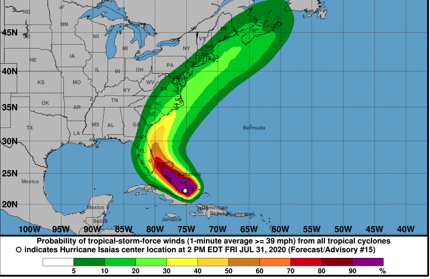
After the powerful storm system’s track shifted again, Hurricane Isaias has increasing potential of impacting South Carolina early next week with anything from dangerous rip currents in Hilton Head to hurricane-force winds in Myrtle Beach.
On Friday, Hurricane Isaias was spinning toward the Bahamas — roughly 900 miles from Beaufort, South Carolina — as a Category 1 storm, unleashing 75 mph winds and moving at speeds of around 17 mph in a northwestern direction, according to the National Hurricane Center‘s (NHC) latest 5 p.m.update. A hurricane warning is in effect for portions of the southeast Florida coast.
“Strengthening is expected later tonight and early Saturday, and Isaias is forecast to remain a hurricane for the next couple of days,” the NHC said in its Friday evening update.
The latest NHC track predicts that Isaias will make landfall in Florida and weaken the system before its near South Carolina.
Gov. Henry McMaster said Friday afternoon that South Carolina residents, especially those on the coast, should prepare for the storm, but he had “no intention” of issuing an evacuation order.
The forecast for South Carolina remains highly uncertain due to Isaias’ shifty track.
Here’s the latest NHC track as of 5 p.m. Friday. The track slightly shifted west on Friday afternoon, but is expected to weaken into a tropical storm.

Hiton Head, Charleston, and Myrtle Beach are well within the latest “cone of uncertainty.” The latest NHC track looks better for the Midlands with minimal impact — but that could change in the next few days as half of it is in the cone.
The “cone of uncertainty” is a five-day outlook based on historical data projecting a 60-70 percent chance the tropical cyclone will remain within the track during that time frame.
Considering that a third of hurricanes fall outside of these projected cones, it’s important to note that this storm’s track is still widely unknown.
If Hurricane Isaias stays well off the coast as the NHC predicts, South Carolina’s beaches can expect to see less-than-tropical-storm-force winds (below 25 mph) with the most serious gusts around Myrtle Beach and weaker wind speeds in the southeast part of the state (Hilton Head and Charleston), Malsick said.
Based on the current track, the National Weather Service -Charleston forecasts for the coastal areas of Hilton Head, Beaufort, and Charleston to expect the following between Sunday through Monday:
- Rip Currents: Dangerous rip currents expected, beginning Saturday and continuing through the event.
- High Surf & Beach Erosion: Moderate to major beach erosion Sunday through Monday becoming more likely.
- Coastal Flooding: Possibility of significant inundation along the SC/GA coast, especially during each high tide cycle Sunday evening through Monday evening, especially along/near the Charleston County Coast. More significant inundation would be likely if storm is stronger and tracks closer to the coast.
- Winds: Potential for tropical storm force winds, especially along the immediate southeast South Carolina coast and in the Charleston Tri-County area. The strongest winds are expected late Sunday night and Monday. These winds could cause minor structural damage, knock down trees and result in isolated power outages.
- Flooding Rainfall: The threat for heavy rainfall and potential flash flooding is possible Sunday night and Monday. The greatest threat expected near the southeast SC coast and in the Charleston Tri-County area.
- Tornadoes: Potential for isolated tornadoes Sunday and Monday, mainly along the immediate southeast SC coast and in the Charleston Tri-County area.

Because the storm is still a long ways from South Carolina, Hurricane Isaias’ track could still change.
“West-east track tweaks are possible as the ECMWF, GFS and Canadian GEM operational runs have walked the track back east overnight uncomfortably close to the South Carolina coast,” Mark Malsick of the S.C. Climate Office said Friday.
Take a look at the spaghetti models for the storm..

As Malsick pointed out, some models track Isaias hugging the South Carolina coast as a Category 1 hurricane or a tropical storm and some even predict a landfall between Hilton Head and Charleston…

And some models still track Isaias running up the west coast of Flordia.

“Florida may only get skimmed by the storm this weekend but the Carolina coast, which sticks out farther to the east is still vulnerable for a possible landfall early next week,” AccuWeather senior meteorologist Alan Reppert said Friday morning. “It will be losing wind intensity by that time though, but it still will bring rain, wind and rough surf, especially to the Florida and Carolina coastline.”
According to AccuWeather meteorologists, Isaias has a large footprint with tropical-storm-force winds reaching up to 200 miles from its center. This means that the east half of South Carolina from the Midlands to the coast should be watching this storm closely this weekend. Columbia, Hilton Head, and Charleston could see wind gusts of up to 60 mph through Monday.

As for rainfall, AccuWeather predicts Hilton Head, Beaufort, Charleston, and Myrtle Beach should see about 2-4 inches of rain from Sunday to Tuesday, while Columbia and the Midlands may get 1-2 inches of rain.
Even if South Carolina is spared the brunt of Isaias’ fury, the Palmetto State would be wise not to let its guard down. According to a new report from Accuweather, its hurricane team has increased its forecast for named tropical systems – calling for an estimated four-to-six major hurricanes in what it is referring to as a “hyperactive” season.
We will continue to closely monitor Isaias as it strengthens in the Atlantic…

*****
ABOUT THE AUTHOR..

Mandy Matney is the news director at FITSNews. She’s an investigative journalist from Kansas who has worked for newspapers in Missouri, Illinois, and South Carolina before making the switch to FITS. She currently lives on Hilton Head Island where she enjoys beach life. Mandy also hosts the Murdaugh Murders podcast. Want to contact Mandy? Send your tips to mandy@fitsnews.com.
