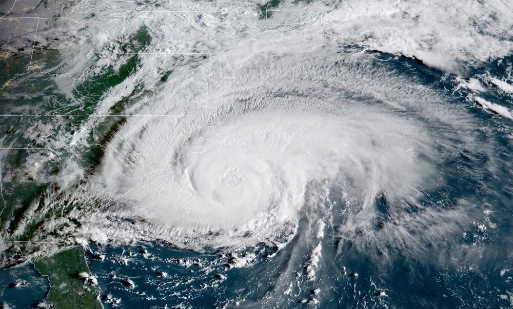
After a week of hype and hoopla, Hurricane Florence is finally here.
The monster storm – which briefly flirted with category five status on its march across the Atlantic – was located roughly 170 miles southeast of Wilmington, North Carolina as of 8:00 a.m. EDT Thursday. Landfall on the coastline of the Tar Heel State is imminent.
The good news? Florence has weakened considerably over the last 24 hours. With maximum sustained winds of 110 miles per hour, she is now a category two system – no longer a “major” hurricane.
The bad news? The still-dangerous storm is slowing down … and is expected to take a leisurely “fish hook” dip through South Carolina after coming ashore somewhere between Carolina Beach, N.C. and Emerald Isle, N.C. sometime around 2:00 a.m. EDT. Such a slow, meandering trajectory could create devastating storm surges and flooding from Georgetown S.C. all the way to the North Carolina-Virginia border.
Severe inland flooding is also forecast for the Palmetto State, which is expected to see Florence drift through its Pee Dee, Midlands and Upstate regions on Saturday and Sunday.
“Do not focus on the wind speed category of Hurricane Florence!” the National Hurricane Center (NHC) in Miami, Florida wanted in a tweet. “Life-threatening storm surge flooding, catastrophic flash flooding and prolonged significant river flooding are still expected.”
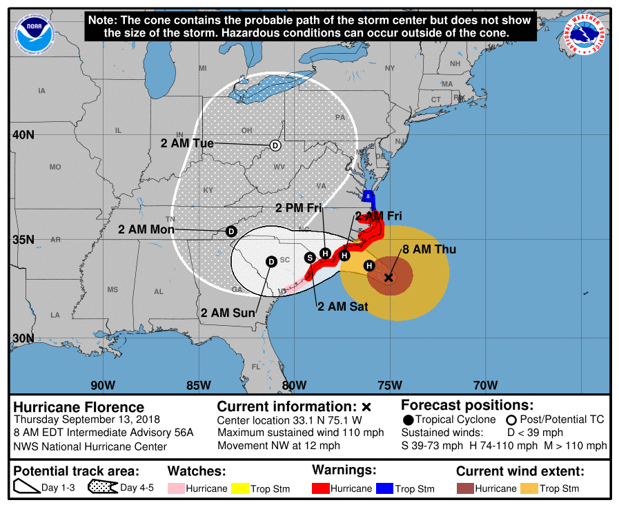
Here is the latest forecast bubble for the storm …
(Click to view)
(Via: NHC)
“Florence is moving slower toward the northwest at about twelve miles per hour,” the latest advisory from the NHC noted. “This general motion, accompanied by a further decrease in forward speed, is expected to continue through today. A turn to the west-northwest and west at an even slower forward speed is expected tonight and Friday, and a slow west-southwestward motion is forecast Friday night and Saturday.”
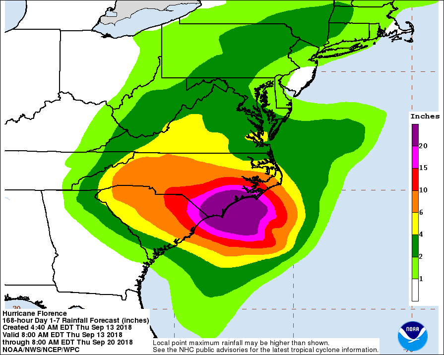
An estimated 20-30 inches of rainfall is projected for coastal North Carolina and northeastern South Carolina – with up to forty inches in isolated areas. Meanwhile inland regions of the Palmetto State, North Carolina and Virginia are expected to see 6-12 inches of rain, with up to two feet falling in isolated areas.
Here is a look at the latest rainfall projections …
(Click to view)
(Via: NHC)
“This rainfall would produce catastrophic flash flooding and prolonged significant river flooding,” NHC forecasters warned.
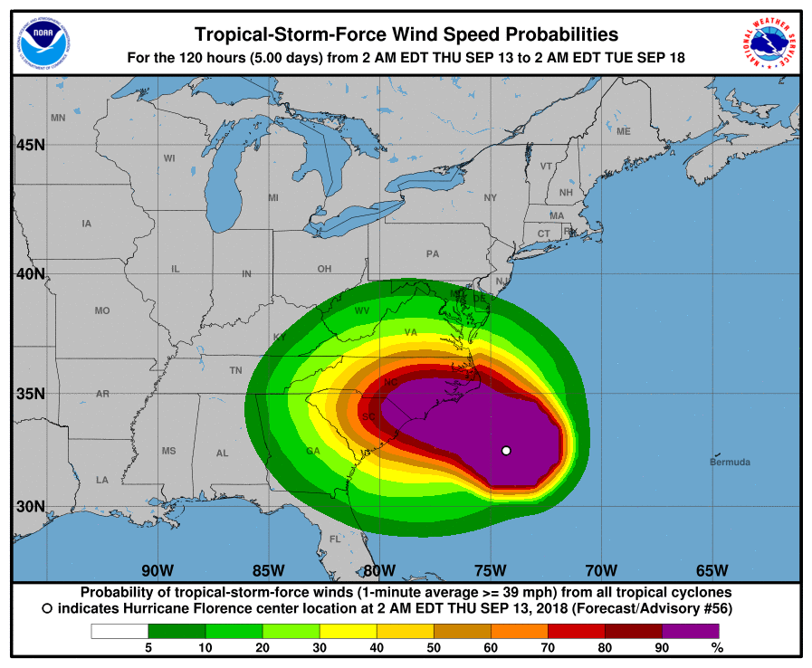
A large tropical system, hurricane-force winds extend outward from Florence’s center of circulation for eighty miles. Tropical storm-force winds extend outward for up to 195 miles.
“Hurricane conditions are expected to reach the coast within the hurricane warning area (Thursday) evening or early Friday,” the NHC warned.
Here is a look at the latest wind speed probabilities over the next few days…
(Click to view)
(Via: NHC)
Emergency management officials in South Carolina pleaded with those still on the coast to heed mandatory evacuations issued three days ago.
“Public safety agencies will begin moving staff (and) equipment to safe locations,” officials with the S.C. Emergency Management Division (SCEMD) noted early Thursday. “Residents have just a few hours to safely leave areas vulnerable to Hurricane Florence.”
***
***
WANNA SOUND OFF?
Got something you’d like to say in response to one of our stories? Please feel free to submit your own guest column or letter to the editor via-email HERE. Got a tip for us? CLICK HERE. Got a technical question or a glitch to report? CLICK HERE. Want to support what we’re doing? SUBSCRIBE HERE.
Banner: Text
