In the world of #FakeWeather nothing is certain, but the latest forecast track for newly christened tropical storm Nate is looking a bit better for residents of Florida and South Carolina.
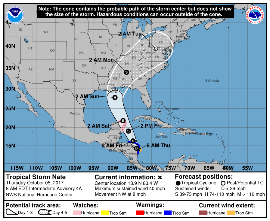
Formerly known as tropical depression sixteen, Nate’s initial forecast assumed a landfall in Florida’s Big Bend region sometime Sunday afternoon followed by a slog through Georgia and South Carolina early Monday.
According to the latest projections from the National Hurricane Center (NHC) in Miami, Florida, the storm’s potential landfall has shifted to the west. Now forecasters see Nate drawing a bead on the gulf coasts of Louisiana, Mississippi and Alabama early Sunday morning before curling off to the northeast on Monday.
Take a look …
(Click to view)

(Via: NOAA)
As of this writing, Nate is located approximately ten miles south of Puerto Cabezas, Nicaragua. Its maximum sustained winds are 40 miles per hour and the system is moving northwest at eight miles per hour. Nate is projected to remain a tropical storm until it clears the Yucatan peninsula sometime early Saturday.
It is expected to gain hurricane strength upon entering the Gulf of Mexico.
Where will it go? And how strong will it be when it gets there? We don’t know yet …
But as we noted in our prior coverage, “this is absolutely the last thing the country needed right now.”
Budget-busting mega-hurricanes Harvey and Irma have already battered the continental United States – shattering records in the process. Meanwhile monster storm Maria did catastrophic damage to Puerto Rico.
What fresh hell will Nate bring?
We don’t know yet, but it’s clear at this point the American mainland is going to face another direct hit …
***
WANNA SOUND OFF?
Got something you’d like to say in response to one of our stories? Please feel free to submit your own guest column or letter to the editor via-email HERE. Got a tip for us? CLICK HERE. Got a technical question? CLICK HERE. Want to support what we’re doing? SUBSCRIBE HERE.
Banner via iStock
