The forecast track for powerful Hurricane Irma continues to bode poorly for the eastern United States – specifically Florida, Georgia and the Carolinas.
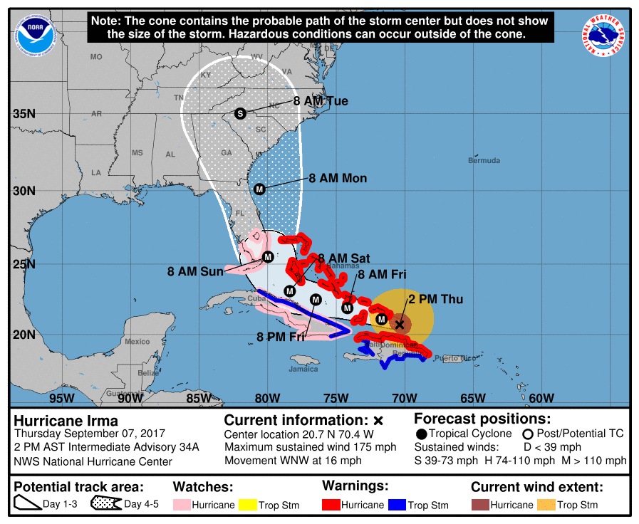
According to the latest advisory from the National Hurricane Center (NHC) in Miami, Florida, Irma is located roughly 65 miles north-northeast of Puerto Plata in the Dominican Republic. It is moving west-northwest at approximately sixteen miles per hour.
The storm’s strength continues to dip incrementally, but it remains one of the most powerful tropical cyclones ever recorded – packing maximum sustained winds of 175 miles per hour. That’s a bit weaker than its peak intensity of sustained winds of 185 miles per hour (last recorded at 11:00 p.m. EDT on Wednesday evening) but Irma remains a strong category five system on the Saffir-Simpson scale.
“Some fluctuations in intensity are likely during the next day or two, but Irma is forecast to remain a powerful category four or five hurricane during the next couple of days,” NHC forecasters warned.
While Irma’s maximum sustained winds have dipped modestly, the storm is growing. Hurricane force winds now extend outward more than sixty miles from the center of circulation – while tropical storm force winds extend outward for 185 miles.
Here’s a look at its latest forecast window …
(Click to view)

(Via: NOAA)
As we noted earlier today, this forecast track represents “a worst case scenario situation – with the upper Florida Keys and Miami taking direct hits and the coastlines of upper Florida and Georgia getting sideswiped prior to Irma making a second landfall in the South Carolina Lowcountry.”
Assuming that happens, we are talking about a storm that could cause more destruction than 1992’s Hurricane Andrew and 1989’s Hurricane Hugo … combined.
***
RELATED: HURRICANE HISTORY
***
Obviously we are still four days away from Irma possibly making a South Carolina landfall – meaning there is still a chance the storm’s projected path could change – but with each new advisory, it certainly seems as though the system is drawing a bead on the Palmetto State.
In anticipation of Irma’s arrival, state and local officials are in the process of closing offices and cancelling classes at government-run schools. There are also plans in the works to reverse both eastbound lanes of Interstate 26 in an effort to accommodate traffic moving off of the South Carolina coast – as was done in October 2016 prior to the arrival of Hurricane Matthew.
***
WANNA SOUND OFF?
Got something you’d like to say in response to one of our stories? Please feel free to submit your own guest column or letter to the editor via-email HERE. Got a tip for us? CLICK HERE. Got a technical question? CLICK HERE.
Banner via iStock
