STORM WINDOW SHIFTING OUT TO SEA …
The forecast track for powerful Hurricane Matthew remains uncertain, but the latest advisory from the National Hurricane Center in Miami, Florida seemed to suggest a continuation of Wednesday morning’s improved outlook.
At least for the Carolinas …
Matthew’s most recent weekend forecast – released at 11:00 a.m. EDT on Wednesday – showed the projected path of the storm continuing to move farther off the coast of both North Carolina and South Carolina.
Should the storm continue to follow this trajectory, it would obviously be welcome news to residents in both the Tar Heel and Palmetto States.
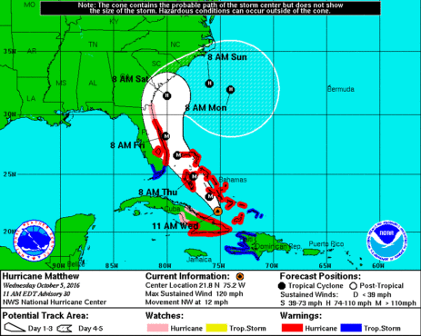
First, here is Matthew’s latest five-day forecast window …
(Click to enlarge)
(Via NOAA)
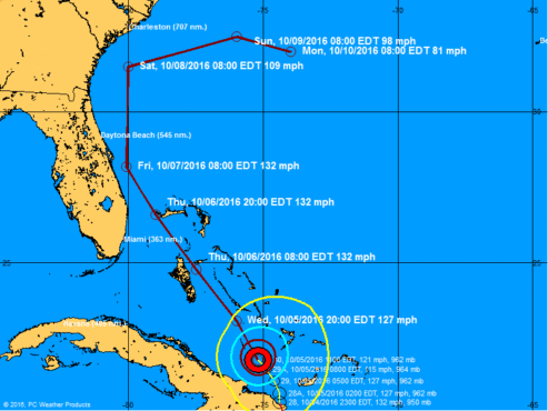
And here is the storm’s most recent projected forecast track …
(Click to enlarge)
(Via NOAA)
Obviously neither of the Carolinas are out of the woods. As we noted in our previous coverage, broad swaths of South Carolina’s Lowcountry, Pee Dee and Grand Strand regions remain in the storm’s extended “bubble.”
Also, even if both states manage to avoid a direct hit there will still be strong winds and severe flooding associated with a “near miss.”
And last but not least, forecasts change.
Accordingly, S.C. governor Nikki Haley is proceeding with a mandatory evacuation of six coastal counties: Beaufort, Berkeley, Charleston, Colleton, Dorchester and Jasper.
That evacuation – which will include lane reversals on Interstate 26 and other major thoroughfares – is scheduled to commence at 3:00 p.m. EDT. Residents in Georgetown and Horry counties are scheduled to begin evacuations on Thursday morning.
Haley has received some criticism from those who believe she initiated mass evacuations too early. While the efficacy of her decision remains to be seen, we find it difficult to criticize her in this situation (and this website is arguably Haley’s most vocal critic).
As far as we can tell, she is making the correct decisions based on the information available to her at the time – erring on the side of abundant caution.
(Banner image via iStock)


