|| By FITSNEWS || How bad is the drought in the Western United States? Real bad …
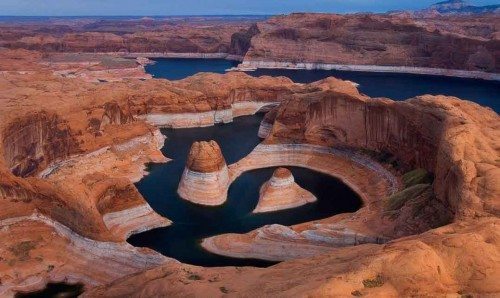
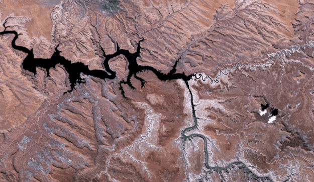
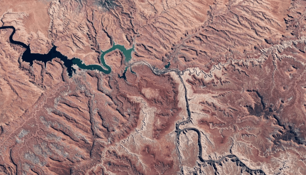
To wit: Here’s satellite imagery of Lake Powell, a reservoir on the border of Utah and Arizona which provides water for Nevada, Arizona and California (for now).
First, here’s Lake Powell in 1991 …
(Click to enlarge)
(Pic via NASA)
Now, here’s the lake this year …
(Click to enlarge)
(Pic via NASA)
Wow …
Don’t worry, though (sarcasm alert). The Environmental Protection Agency (EPA) is on the case …


22 comments
Hey, at least it’s not orange.
Gee, I wonder if that has anything to do with diminishing run off from ice pack?
I can’t see what’s the problem.
http://cdn2.hubspot.net/hub/125564/file-16859345-jpeg/images/powell15.jpeg?t=1441747057401
Precious little news from the Hildale flash floods, but if it doesn’t help out Lake Powell, it certainly should help out Lake Mead (also greatly diminished in volume). Yes, it will be orange – at least on the northern end – but it won’t be quite so full of mine tailings as is the EPA Special near Durango, CO. If the UT flash floods’ rain source kept moving east, it would have rained in the Lake Powell catchment area, and at least given some relief. Page, AZ (Lake Powell’s Damsite) and Hildale, UT are about 100 miles apart.
Was out that way on an extended motor trip in June – not really very much different from normal (April is the month that most of the western reservoirs fill from snowmelt). Lake Mead has been drying steadily for years since it nearly overtopped back in 1884 or ’85. Was there then, and the spillways were running over at almost full capacity (and they had decided to plug the penstocks installed when built). The lake had not been full since the test filling in the late 1930s. May never be full again within our lifetime.
Note also that the older picture (1991) shows the Navajo steam plant (coal-fired) in full operation (the two white clouds on the right side of the picture) and the lack thereof in the 2015 picture. It is being/has been closed down – a fully automated railroad from mine to generator along with it.
Takes a whole lot less water to make steam (which can be recondensed and used as water again) than it does to let it run thru the turbine at the hydro plant and go on downstream (or to California’s grass).
After all, Lake Murray has a hydro plant that is rarely (if ever) used at capacity – I WONDER if the reason why is that (1) it has been “paid for” through tax amortization, or, (2) because the water is “free”, or (3) SCANA can more or less double dip by charging for the new natural gas turbines (and for the gas, since they will be basically selling to themselves) they are planning to install, or (4) from the little new nukies that never hurt anyone that keep increasing in price.
FitsNews and Zero Hedge fooled you, too. The pictures have been rotated 90 degrees so that north is at the right, and those are clouds in the 1991 picture that are 97 to 100 miles NE of the Navajo Steam Plant.
I rode my motorcycle past that automated train for miles in 2007 after a ride thru Monument Valley. Depending on the wind, that plant spoiled the views from Grand Canyon to Monument Valley and beyond. From the looks of Google Earth images from April 2015, it is still running.
Typo “1984 or ’85”
Select averages per year. 2004 was much worse than current levels.
http://lakepowell.water-data.com/index2.php
Thanks – looks like there’s a whole lot more water (+14 feet or so low pool, +54 feet or so high pool) than there was in 2014. I admit, however, that hydrology is not my major, Colonel.
Come on in,the water’s fine
Sorry: gotta call BS here. If you want to see Lake Powell today, go here: https://www.google.com/maps/@37.0690386,-111.1199076,46263m/data=!3m1!1e3
I have no idea what Will is showing.
You and your fucking facts! You ruined a perfectly good panic piece!
Certainly you’re not implying Ol’ Sic is full of shit? Does that follow the implication there’s a drought and somehow that’s the EPA’s fault?
Your information/photo is not current. It is many years old … This is the lastest >>> http://www.zerohedge.com/news/2015-09-17/decades-long-megadrought-looms-entire-us-lake-powell-runs-dry-nasa-warns
Your link is to the source of Will’s bogus images — Zero Hedge — which do not look anything like the Lake Powell available on Google I linked to. That image date is 6 April 2015.
Still having an identity crisis, I see.
Follow the river on the Google maps link northeast to the town of Hite. That’s the portion of the lake depicted
Imagine how little water there would be if the big bad gubamint had not built all those dams.
Wowee. See all of those other dry stream beds? Water comes; water goes. Temperatures rise; temperatures fall. Man affects the environment; the environment affects man. It’s been this way since the Big Bang (minus the “man” part, of course), and will be this way until everything wraps.
Old sat photo, evil hate filled man.
That’s deep, brother. Deep.
And just what do you propose as a solution FITS????
Arm chair coaching won’t cut it and that’s a fact!!!
Willie’s solution is to burn more coal and gas. Otherwise, we might wreck the economy.